Cadastral Applications
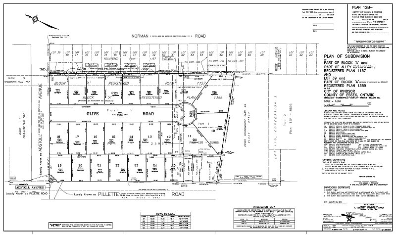

Plans of Subdivision
M-plan (Registered in the Land Titles system)
Registered Plan (RP) (Registered in Registry system)
Upon registration in the Land Registry Office, after appropriate approvals have been obtained, these plans subdivide property into two or more new parcels, units, or lots and set out the boundaries of these new lots for the first time. The approval process is governed by section 51 of the Planning Act RSO 1990 Ch. P.13 and includes consideration of where streets, parks and dwellings will be located. A registered plan of subdivision shows: the surveyed boundaries, numbering and dimensions of lots, the location, width and names of streets, and the sites of future schools and parks. These plans do not show specific building locations.
A plan of subdivision must be surveyed by a licensed Ontario Land Surveyor.
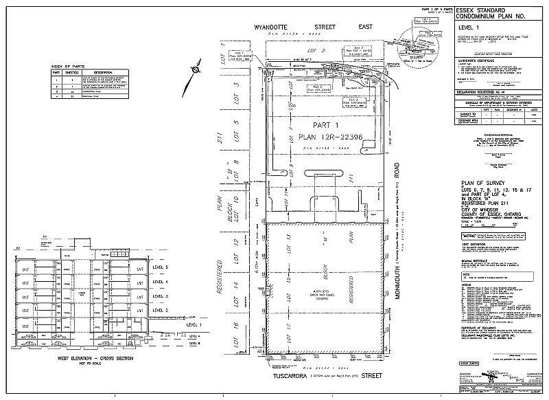
Condominium Plans
A Condominium Plan is also a plan of subdivision, which creates new parcels of land called Units. The major difference is that, except in the case of a vacant land condominium, the units are three-dimensional, with the boundaries being the physical surfaces of the buildings themselves. Since units may be located above and below each other, the legal description of the parcel must specify the Unit Number, Level Number and Plan Number. Unit owners share the ownership and the cost of maintaining the parts of the condominium that are not units.
Condominium Plans must be prepared by a licensed Ontario Land Surveyor.
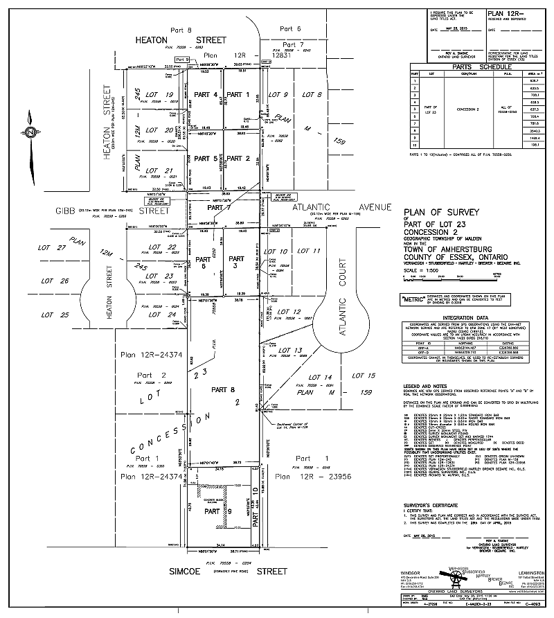
Reference Plans (R-plans)
These plans are deposited in the local Land Registry Office and are graphical representations of descriptions of land, as well as representations of divisions of land under the Planning Act RSO, 1990 Ch.P.13. A reference plan is necessary for a severance. Each Land Registry Office has a unique number, and reference plan numbers include the number of the office in which they are deposited. Reference plans show the surveyed boundary and dimensions as well as any physical or documentary evidence that could affect the title to the property. This may include the location of fences, hedges, retaining walls, overhead wires, etc. in relation to the boundaries and any easements or rights-of-way that are evident or that are registered on title. Buildings or other improvements on the property are generally not shown unless they were used to position the boundary or they encroach on the property.
A reference plan must be surveyed by a licensed Ontario Land Surveyor.
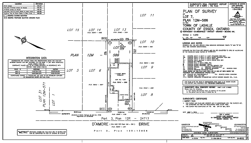
Surveyor’s Real Property Report (SRPR)
This is a plan of survey and report prepared under Sections 26, 27 and 28 of O.Reg. 42/96 of the Surveyors Act, RSO, 1990 Ch. S.29. A SRPR is prepared specifically to illustrate the location of buildings or structures relative to the boundaries of a unit of land. It also shows the location of any other physical features and registered encumbrances, such as easements, on or immediately adjacent to the property. In a Real Estate transaction, a current Surveyor’s Real Property Report provides the purchaser, the seller, the lending institution, the municipality, the Realtor and all other parties to the transaction with an accurate representation of the property prior to the purchase being completed. A Surveyor’s Real Property Report must be prepared by a licensed Ontario Land Surveyor.
see Surveyor’s Real Property Report Brochure
Other Applications
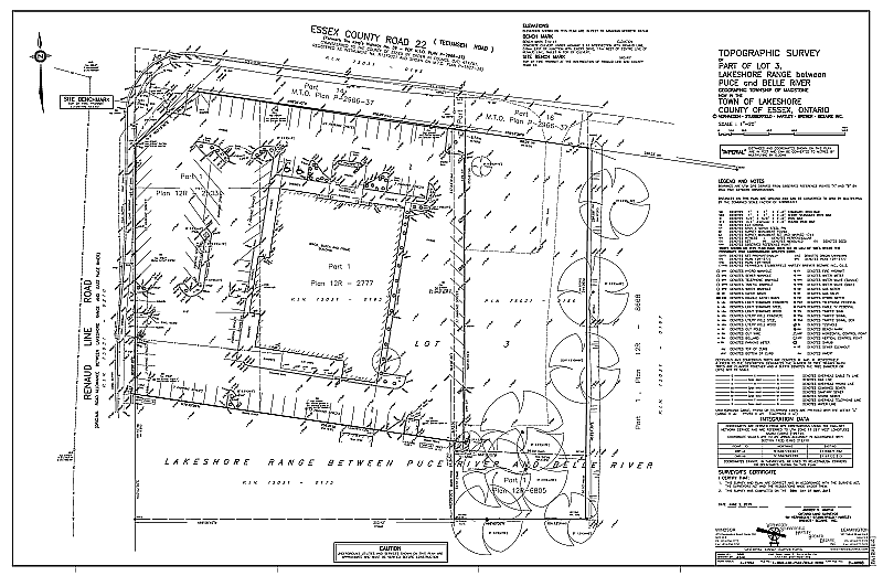
Topographic Surveys
Topographic surveys are plans that show the physical properties of a site. These plans may be used by Engineers and Planners to assist with the design of a development proposal, but are not the plans used for the development application. A topographic survey may compliment a development application. It shows the physical constraints that the proponent must consider in a development application, or a detailed design of a site for development purposes. The surveyor often provides the topographic plan, which shows vertical elevations or contours, as well as physical details above, on and below the ground. Contours are lines on the drawing that join points that have the same elevation on the ground. Contour lines never cross each other, and the closer the lines are to each other, the steeper the slope. Conversely, the further apart the lines are from each other, the flatter the slope.
Applications of Geographic Information Systems (GIS)
GIS is not just an improved, digital version of the traditional paper map, it is much more. GIS involves the collection and analyzing of spatial and other data as they relate to specific geographic entities, rather than simply displaying them on a map. The data related to a property might include the lot area, address, owner’s name, type of house, number, age and gender of occupants, school support, assessment value, type of soil and so on. Intelligent use of this data makes GIS a very powerful tool.
Verhaegen Land Surveyors is a Member of the Association of Ontario Land Surveyors.